


11 Millersville Voting District, Sumner County, Tennessee
About
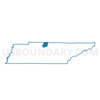
Outline

Summary
| Unique Area Identifier | 669835 |
| Name | 11 Millersville Voting District |
| County | Sumner County |
| State | Tennessee |
| Area (square miles) | 13.68 |
| Land Area (square miles) | 13.68 |
| Water Area (square miles) | 0.00 |
| % of Land Area | 100.00 |
| % of Water Area | 0.00 |
| Latitude of the Internal Point | 36.39165560 |
| Longtitude of the Internal Point | -86.70238800 |
Maps


Graphs
Select a template below for downloading or customizing gragh for 11 Millersville Voting District, Sumner County, Tennessee


Neighbors
Neighoring Voting District (by Name) Neighboring Voting District on the Map
- 04 Cottontown Voting District, Sumner County, TN
- 04-1 Ridgetop Adventist Elem. Voting District, Robertson County, TN
- 10-1 Luton's UMC Voting District, Davidson County, TN
- 11 Hunter Voting District, Sumner County, TN
- 11 Madison Creek Voting District, Sumner County, TN
- 12 White House Middle School Voting District, Sumner County, TN
Top 10 Neighboring County Subdivision (by Population) Neighboring County Subdivision on the Map
- District 10, Davidson County, TN (18,165)
- District 4, Sumner County, TN (13,739)
- District 12, Sumner County, TN (13,384)
- District 11, Sumner County, TN (13,206)
- District 4, Robertson County, TN (5,261)
Top 10 Neighboring Place (by Population) Neighboring Place on the Map
- Nashville-Davidson metropolitan government (balance), TN (601,222)
- Goodlettsville city, TN (15,921)
- Millersville city, TN (6,440)
- Shackle Island CDP, TN (2,844)
- Ridgetop city, TN (1,874)
Top 10 Neighboring Unified School District (by Population) Neighboring Unified School District on the Map
- Nashville-Davidson County School District, TN (626,681)
- Sumner County School District, TN (160,645)
- Robertson County School District, TN (66,283)
Top 10 Neighboring State Legislative District Lower Chamber (by Population) Neighboring State Legislative District Lower Chamber on the Map
- State House District 45, TN (72,256)
- State House District 44, TN (70,843)
- State House District 66, TN (66,283)
- State House District 50, TN (60,711)
Top 10 Neighboring State Legislative District Upper Chamber (by Population) Neighboring State Legislative District Upper Chamber on the Map
Top 10 Neighboring 111th Congressional District (by Population) Neighboring 111th Congressional District on the Map
Top 10 Neighboring Census Tract (by Population) Neighboring Census Tract on the Map
- Census Tract 210.05, Sumner County, TN (6,203)
- Census Tract 806.06, Robertson County, TN (5,883)
- Census Tract 204.07, Sumner County, TN (4,068)
- Census Tract 210.04, Sumner County, TN (3,707)
- Census Tract 102.02, Davidson County, TN (3,530)
- Census Tract 210.06, Sumner County, TN (3,145)